Monday, March 16, 2009

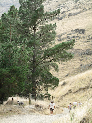
Huntsbury Walkway

Difficulty rating: 4/10 (short walk, moderate fitness required, incline, decline, little flat terrain)

link to other TRACKS

The Huntsbury Track follows an old farm track still in use by park rangers and possibly still farmers. It is a great walk if you are looking for a short but interesting track. It is approximately 4 km's (up and down) long and will bring you out on Summit Rd should you get to the top.

Like all of the walks, tracks 'n trails in the Port Hills, the Huntsbury offers great views.

This is a good walk to tackle if you are looking for a walk to get your fitness levels up without breaking your back or feet.

Pro's: short, good views
Con's: short

link to other TRACKS
Mount Vernon Track

Difficulty rating: 6/10 (moderate fitness required, incline, decline and flat terrain)

back to other TRACKS

The Mount Vernon Track is an interesting one as it can be completed in various ways. The Rapaki Track leads to Summit Rd and then on to Mount Vernon should you wish. Alternatively, you can complete the 6.5 km walk by following the valley which runs to the right of the Rapaki trail.

I have found the track far more interesting by making the ascent using the track that follows the valley and coming down (descent) via the Rapaki Track. Should you do this and need to get back to the valley floor and parking area, look out for Rogers Track on your left as you make your descent, this will bring you back down into the valley and near the parking area.

"
Mt Vernon Park is a good place to explore the easier slopes of the Port Hills. The carpark is nestled snugly in a valley with many short walks up to lookouts, a plane table and a track through a gorge. Longer tracks link up with Rapaki Track, and onto the summit of Mt Vernon itself, where there is the Lamar accessible walk beside the Summit Road. The park is managed by the Port Hills Park Trust." quoted from the Christchurch City Councils website.

Pro's: good easy walking with varied terrain, great views, circular route option, good workout

Con's: for the not-so-fit it can be a bit of a climb, weather can change very quickly.

Tips: take plenty of water, sunblock, good walking shoes (boots not essential), keep valuables in car out of sight (break ins do happen).

Back to other TRACKS

Useful gps links for New Zealand

You may find the following links useful if you are interested in maps or gps navigation. I will update this page regularly. If you have any other useful and relevant links please get in touch or add your comments.

http://nzopengps.org/
Free autorouting, street number searchable maps of New Zealand for Garmin mapping GPS. The street maps cover the whole of New Zealand with just about every road and street named in the country (except the Chatham Islands). These maps are free - do not pay for them!

http://www.nztopoonline.linz.govt.nz/
Land Information New Zealand (LINZ) is a New Zealand government department responsible for land titles, geodetic and cadastral survey systems, topographic information, hydrographic information, managing Crown property and a variety of other functions.

http://www.geographx.co.nz/
Geographx is a digital mapping company with a reputation for boldness and innovation. Based in Wellington and with a New Zealand focus, our interest extends to Australia, Antarctica, the Pacific Islands and the Asia-Pacific rim.

The Rapaki Track

Difficulty rating: 6/10 (moderate fitness required, incline, decline and flat terrain)

The Rapaki Track is a fantastic walk and you don't need to be super fit to get stuck into it either. It's roughly 6.5 km's long (if you complete both the ascent and descent) and hugs the left side of the Mount Vernon "valley". The track is very popular with both mountain bikers and walkers alike and offers varied terrain.

You can expect a winding dirt road with beautiful views over looking Christchurch city. Eventually you will arrive at Summit Rd which follows the length of the Port Hills summit and like most of the tracks or trails in the area, offers fantastic views of both Christchurch, on the north side of the hills, and Lyttleton/ Governers Bay, on the south side.

The track itself is an old farm track and is currently undergoing road works after which it will be open to vehicles. For now though, it is still open to trampers and cyclists.

Pro's: good distance for getting a decent workout, varied terrain, great views, suitable for people of moderate fitness upwards.

Con's: none really. The usual conflicts between walkers and cyclists but everyone seems to be very tolerant and friendly (so no issues). May offer the occasional blister.

Tips: good shoes/ boots, sunblock, the top of summit rd has great viewing spots so is worth considering as a picnic or photographers spot. Take a camera.

To view photo's click here.

Back to other TRACKS.

The Bridal Path - Christchurch, New Zealand

                                                      © Ian Stansfield Photography 2010


Difficulty rating: 7/10 intense but short (plenty of incline/ decline - little flat terrain)

The Bridal Path in the Port Hills near Christchurch is an intense 1.4km walk (one way) to the summit from the parking lot on the Gondola side. This was the first walk that Kelly and I completed on our arrival in Christchurch and considering our fitness levels at the time wasn't one of our favourites, however, we recently revisited this track and didn't find it quite as tough as we recalled but it won't suit anyone looking for flat terrain.

If you start from the foot of the Port Hills you are met with a steep, intense incline that winds its way toward Summit Rd. This walk although short is not for those people wanting a relaxing stroll. The Bridal Path is short and severe. Expect blisters if you haven't worn your boots or shoes in.

If you then head down the other side into Lyttleton you follow a similar winding, and at times steep, descent for 1.8 or so kilometres, which is pleasant enough, but watch out for loose gravel as losing your footing at times is a distinct possibility. Total distance from parking lot (ChCh side) into Lyttleton itself is approximatley 3.45km's, round trip 7.9km's.

Pro's: Excellent workout, brilliant views over Lyttleton from the top (Summit Rd), beautiful scenery

Con's: Excellent workout (unfit people will need to take their time), may induce blisters.

Tips: Take your time and have plenty of water breaks if you aren't in fighting condition. Remember sunblock, hat/ cap, good walking shoes or boots.

Back to other Tracks                                                       
                      More Photo's

Sunday, March 15, 2009

Tracks 'n Trails around Christchurch, New Zealand.

PLEASE GET IN TOUCH IF YOU HAVE ANY TIPS OR TRACK INFORMATION TO ADD!
... and more to follow (with links and photo's etc)

You will shortly be able to find gps files for tracks here:
http://sites.google.com/site/stansfieldnz/tracks-n-trails-1

Wednesday, March 11, 2009

Emmigrating to New Zealand?


I just thought that I would put out a welcome to anyone considering emmigrating to New Zealand that may need some hand holding or advice.

My wife and I have recently made the move from the UK and to be honest it took a massive effort to put ourselves in a position where a move was even possible. It isn't an easy process but if you are looking at your options and want to know what is involved, what are the potential pitfalls and what to expect, by all means get in touch. If I can help, let me know. Regards, Ian

Wednesday, March 4, 2009

The Cook Islands - Heaven on Earth


Kelly and I were blown away by how beautiful the Cook Islands were. We were fortunate to have visited both Rarotonga and Aitutaki en-route to New Zealand (via the infamous LAX) and found our own bit of heaven on earth.

You can find more of our photo's at www.ianstansfieldphotography.com